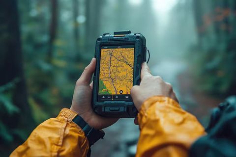
Global positioning technology has become a common part of everyday life. Devices used for navigation, logistics, and location monitoring often depend on components known as GPS tracking modules. These modules receive signals from satellites and determine the geographic position of an object, vehicle, or device.
A GPS tracking module is a compact electronic component designed to calculate location using signals from the satellite network operated by the Global Positioning System. Once the location is calculated, the information can be transmitted to other systems such as monitoring platforms, mapping tools, or data dashboards.
The technology originally developed for navigation and defense purposes. Over time, it became widely integrated into transportation systems, logistics infrastructure, environmental monitoring, and industrial equipment. Today, GPS tracking modules are part of many connected systems that collect geographic data in real time or at scheduled intervals.
Modern modules typically combine satellite receivers, communication interfaces, and processing components. These elements work together to determine coordinates, track movement, and send location information to connected networks or software platforms.
Importance
Role in Industrial Monitoring
GPS tracking modules play an important role in monitoring physical assets and mobile equipment. Industries that manage vehicles, heavy machinery, or transport infrastructure often rely on location data to understand how resources move and operate.
For example, transportation networks use GPS modules to observe routes, travel patterns, and operational efficiency. By collecting geographic data, organizations can analyze traffic patterns, travel distances, and time spent in different locations.
Improving Visibility in Logistics
In supply chain environments, GPS tracking modules help track shipments, containers, and delivery vehicles. Location data supports better visibility of goods as they move between warehouses, ports, and distribution centers.
Several logistics activities benefit from location awareness, including:
- Fleet monitoring, which records vehicle movement and travel paths
- Shipment tracking, which allows containers or cargo units to be monitored
- Route analysis, which evaluates travel efficiency and transit time
- Equipment tracking, which monitors industrial assets operating in large facilities
These insights help logistics planners understand operational patterns and make informed decisions about transportation networks.
Safety and Operational Awareness
Location tracking also contributes to safety awareness in industrial environments. GPS modules can provide information about the movement of vehicles, field equipment, or remote infrastructure.
For example, construction sites may track machinery operating across large areas. Similarly, energy infrastructure such as pipelines or utility vehicles may integrate GPS modules to monitor movement and equipment usage.
By collecting geographic data, organizations can maintain records of operational activity and understand how equipment is used over time.
Recent Updates
Integration With Internet of Things Systems
Recent technological developments have expanded how GPS tracking modules interact with connected devices. Many modern modules are now integrated into Internet of Things (IoT) environments.
The concept of the Internet of Things allows sensors, machines, and vehicles to share data automatically. GPS modules act as location sensors within these networks, providing geographic context to other operational data.
For instance, a sensor measuring equipment temperature can also include GPS data to indicate where the measurement occurred. This combination of location and environmental data improves monitoring accuracy.
Advances in Satellite Navigation Systems
Satellite navigation technology has expanded beyond the original GPS constellation. Several global navigation satellite systems now contribute to improved accuracy and reliability.
Examples include:
| Satellite System | Operating Region | Purpose |
|---|---|---|
| GPS | Global | Provides positioning and timing signals |
| Galileo | Global | High-precision positioning signals |
| GLONASS | Global | Navigation and timing services |
| BeiDou | Global | Positioning and messaging capability |
Modern GPS tracking modules often support signals from multiple satellite networks. This multi-constellation approach helps improve accuracy, particularly in dense urban environments or locations with partial signal obstruction.
Smaller and More Efficient Hardware
Hardware development between 2024 and 2026 has focused on reducing energy consumption and physical size. GPS modules are now smaller and can be embedded into compact devices such as handheld monitoring equipment, smart sensors, and industrial instruments.
Energy-efficient designs allow devices to operate longer when powered by batteries. This improvement is useful in remote environments such as agricultural fields, mining areas, or environmental monitoring locations.
Laws or Policies
Privacy and Data Protection
Location tracking involves the collection of geographic data, which may be subject to privacy regulations in different regions. Governments and regulatory organizations often establish guidelines for how location information can be collected and stored.
For example, privacy frameworks in regions influenced by the General Data Protection Regulation define how personal data, including location information linked to individuals, must be handled.
These regulations emphasize transparency, data security, and responsible data usage.
Transportation and Fleet Regulations
Transportation authorities in many countries establish rules related to vehicle monitoring and logistics data management. In India, agencies such as the Ministry of Road Transport and Highways have introduced guidelines for vehicle tracking systems used in commercial transport.
Such policies often focus on improving transportation safety and monitoring compliance with transportation regulations.
Satellite Navigation Governance
Satellite navigation infrastructure itself is regulated and maintained by government or international organizations. These systems ensure reliable signals for civilian navigation, aviation, maritime activities, and scientific research.
International coordination helps maintain consistent navigation signals and timing standards that devices around the world rely on.
Tools and Resources
Digital Mapping Platforms
Mapping tools allow GPS tracking data to be visualized on digital maps. One widely used platform is Google Maps, which displays geographic coordinates, routes, and map layers.
These tools help transform raw location coordinates into visual information that is easier to interpret.
Geographic Data Platforms
Mapping and spatial data analysis often involve geographic information systems. An example is QGIS, which allows users to analyze location data, create maps, and process spatial datasets.
Researchers, planners, and analysts often use geographic software to study transportation routes, environmental changes, or urban infrastructure.
Navigation and Timing Information
Satellite navigation information can also be explored through official government resources such as the National Coordination Office for Space-Based Positioning Navigation and Timing. These platforms publish technical information, satellite updates, and documentation related to navigation systems.
Tools and reference materials like these help researchers and engineers better understand satellite positioning technology.
FAQs
What is a GPS tracking module and how does it work?
A GPS tracking module is an electronic component that determines geographic location using signals from navigation satellites. The module calculates coordinates based on timing signals received from satellites and then transmits that location data to other systems for monitoring or analysis.
Where are GPS tracking modules commonly used in industry?
Industries such as transportation, logistics, agriculture, construction, and environmental monitoring use GPS tracking modules. These modules help track vehicle movement, monitor equipment activity, and collect location data for operational analysis.
How accurate are modern GPS tracking modules?
Accuracy depends on several factors including satellite visibility, environmental conditions, and hardware design. Many modern modules improve accuracy by combining signals from multiple satellite systems such as GPS, Galileo, and GLONASS.
Can GPS tracking modules work indoors?
Satellite signals can weaken when passing through walls or dense structures. Because of this limitation, GPS tracking modules generally work more reliably outdoors. Some systems combine additional technologies such as cellular positioning or Wi-Fi signals to estimate location indoors.
What industries benefit from GPS tracking modules?
Industries that manage mobile assets or large geographic areas often use GPS tracking modules. Examples include transportation networks, fleet management systems, construction equipment monitoring, and environmental data collection projects.
Conclusion
GPS tracking modules have become a foundational component in many industrial and technological systems. By receiving satellite signals and calculating geographic coordinates, these modules help monitor movement, track assets, and provide location data across a wide range of industries.
Technological advancements have expanded their capabilities through integration with IoT networks, multi-satellite navigation systems, and energy-efficient hardware designs. At the same time, privacy regulations and transportation policies influence how location data is collected and used.
Understanding how GPS tracking modules operate helps explain their role in modern infrastructure, logistics networks, and data-driven monitoring systems.