LiDAR Sensors Explained: Important Details for Better Accuracy and Performance
LiDAR sensors have become an important part of modern technology because they help measure distance.
The term LiDAR stands for Light Detection and Ranging, a method that uses laser pulses to calculate the distance between a sensor and nearby objects. By collecting thousands or even millions of measurements, LiDAR systems can build highly detailed three-dimensional representations of an environment.
Today, LiDAR sensors are used across transportation, manufacturing, construction, agriculture, environmental research, and robotics. Different designs, including industrial LiDAR sensors, 3D LiDAR sensor technology, and automotive LiDAR sensor systems, have been developed to meet different operating conditions. As computing technology has improved, LiDAR has become more accurate, compact, and suitable for a wider range of applications.
Context
Understanding How LiDAR Sensors Work
A LiDAR sensor emits rapid laser pulses toward surrounding objects. Each pulse reflects back after hitting a surface, and the sensor measures how long the reflection takes to return. Since the speed of light is known, the system can calculate the exact distance to the object.
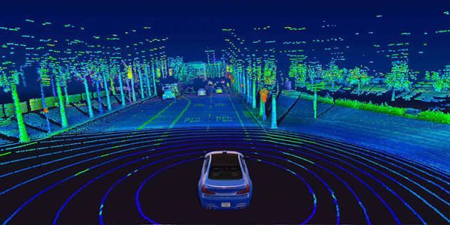
Thousands of these measurements are combined into a digital point cloud. This collection of points forms a detailed 3D representation of roads, buildings, trees, equipment, or other surrounding objects.
Main Components of a LiDAR System
Most LiDAR systems include several important components:
- Laser transmitter that emits light pulses
- Receiver that detects reflected signals
- Optical components that guide the laser
- Positioning sensors such as GPS and inertial measurement units
- Processing software that converts measurements into usable maps
Depending on the intended application, a system may also include a rotating scanner or use solid state LiDAR technology without moving mechanical parts.
Common Types of LiDAR Sensors
Different environments require different sensor designs.
| LiDAR Type | Common Purpose | Typical Features |
|---|---|---|
| Industrial LiDAR sensors | Factory automation | Reliable object detection |
| Automotive LiDAR sensor | Vehicle navigation | Fast environmental scanning |
| 3D LiDAR sensor | Spatial mapping | Detailed three-dimensional models |
| Drone LiDAR sensor | Aerial surveys | Lightweight construction |
| Mobile LiDAR system | Road and city mapping | Data collection while moving |
| Long range LiDAR sensor | Large outdoor areas | Extended measurement distance |
Importance
Improving Measurement Accuracy
Many industries depend on accurate measurements for planning and operation. A laser distance sensor provides highly precise distance information that helps reduce manual measurement errors.
Construction teams can compare completed structures with digital plans, while engineers can inspect equipment positioning with greater consistency.
Supporting Autonomous Technologies
Autonomous vehicle LiDAR systems help vehicles detect nearby objects, road edges, pedestrians, and obstacles. Instead of relying on a single sensing technology, LiDAR often works alongside cameras, radar, and GPS to improve environmental awareness.
Although weather and lighting conditions can influence performance differently across sensor types, combining multiple sensing methods improves overall reliability.
Enhancing Industrial Automation
Industrial laser scanner technology plays an important role in manufacturing and warehouse automation. Machines equipped with industrial LiDAR sensors can monitor movement, detect obstacles, and assist automated equipment in navigating complex workspaces.
This contributes to smoother workflows while helping automated systems operate within defined safety zones.
Expanding Robotics Applications
A robotics LiDAR sensor allows robots to understand indoor and outdoor environments. Robots use LiDAR to identify walls, equipment, shelves, and moving objects while creating maps for navigation.
This capability supports warehouse automation, research laboratories, agriculture, and infrastructure inspection.
Improving Mapping and Surveying
Mapping LiDAR systems have transformed the collection of geographic information. Surveyors, engineers, and environmental researchers use 3D mapping sensors to capture detailed terrain information without manually measuring every feature.
Forests, rivers, transportation networks, and urban developments can all be documented with high levels of detail.
Recent Updates
Smaller and More Efficient Sensor Designs
Recent development has focused on reducing sensor size while maintaining measurement quality. Compact solid state LiDAR designs continue to replace larger mechanical scanning systems in many applications because they contain fewer moving parts.
Smaller sensors also make integration easier in vehicles, drones, and industrial equipment.
Higher Resolution Imaging
Modern high resolution LiDAR systems capture denser point clouds than earlier generations. Increased point density allows software to distinguish smaller objects and produce more detailed digital models.
Higher resolution supports infrastructure inspection, environmental mapping, and autonomous navigation.
Growth of Artificial Intelligence Integration
Artificial intelligence increasingly processes LiDAR data alongside camera and radar information. Instead of analyzing raw point clouds alone, software combines multiple sensor inputs to recognize roads, vegetation, buildings, vehicles, and pedestrians more efficiently.
This trend continues across transportation, robotics, and industrial automation.
Expanded Drone Mapping
Drone LiDAR sensor technology has become more common in surveying, forestry, mining, and environmental monitoring. Lightweight sensors allow aerial platforms to collect detailed elevation information in areas that may be difficult to access from the ground.
This supports faster mapping across large landscapes while reducing the need for extensive manual field measurements.
Improved Mobile Mapping Systems
Mobile LiDAR system technology continues to advance through improved positioning accuracy and faster data processing. Vehicles equipped with multiple sensors can collect detailed road information while moving through urban and rural environments.
These systems assist infrastructure planning, transportation studies, and digital city modeling.
Laws or Policies
Transportation Safety Standards
Many countries regulate autonomous vehicle LiDAR development through transportation safety frameworks. Vehicle manufacturers typically conduct testing according to national road safety requirements before advanced driver assistance features can be deployed.
Because regulations continue to evolve, approval processes differ between regions.
Workplace Safety Regulations
Industrial LiDAR sensors used in factories may need to comply with machinery safety standards established by workplace safety authorities. These regulations focus on safe operation around automated equipment and personnel.
Organizations often evaluate sensor placement, emergency stopping systems, and equipment interaction during implementation.
Laser Safety Classification
Since LiDAR uses laser technology, manufacturers generally classify devices according to internationally recognized laser safety standards. These classifications indicate how laser emissions should be handled under normal operating conditions.
Proper installation and maintenance help ensure systems operate within their intended safety guidelines.
Data Collection and Privacy
Mapping LiDAR systems may collect detailed information about buildings, roads, and public spaces. Privacy regulations in many countries govern how geographic information is collected, stored, and processed, particularly when combined with other location data.
Organizations using LiDAR commonly follow local data protection requirements applicable to their region.
Tools and Resources
Mapping Software
Several software platforms process LiDAR point clouds into usable digital models. Common functions include terrain modeling, elevation analysis, object classification, and surface measurement.
Examples include:
- Cloud point visualization software
- Geographic Information System (GIS) platforms
- CAD applications supporting LiDAR datasets
- Point cloud editing software
Data Processing Utilities
Many organizations use specialized software to clean, organize, and classify LiDAR data before creating maps or engineering models.
Common processing tasks include:
- Noise removal
- Surface classification
- Object recognition
- Coordinate transformation
- Measurement verification
Simulation Platforms
Developers working with autonomous vehicle LiDAR and robotics LiDAR sensor technology frequently use simulation environments to evaluate navigation algorithms before physical testing.
These platforms generate virtual environments containing roads, buildings, pedestrians, and obstacles.
Positioning Technologies
Accurate LiDAR mapping often combines several positioning technologies.
These include:
- Global Navigation Satellite Systems (GNSS)
- Inertial Measurement Units (IMU)
- Real-Time Kinematic (RTK) positioning
- Geographic Information System software
Together, these tools improve positioning accuracy during mobile and aerial surveys.
FAQs
What are LiDAR sensors used for?
LiDAR sensors measure distance using laser light and create detailed three-dimensional models of surrounding environments. They are commonly used in transportation, manufacturing, construction, environmental studies, and infrastructure mapping.
What is the difference between industrial LiDAR sensors and an automotive LiDAR sensor?
Industrial LiDAR sensors are generally designed for factory automation, equipment monitoring, and workplace safety. An automotive LiDAR sensor focuses on helping vehicles detect surrounding objects and support navigation systems.
How does a 3D LiDAR sensor create maps?
A 3D LiDAR sensor sends laser pulses in many directions and measures the reflected signals. Software combines these measurements into a point cloud, which forms a detailed three-dimensional representation of the surrounding area.
What is solid state LiDAR?
Solid state LiDAR uses electronic scanning methods instead of rotating mechanical components. This design may reduce mechanical complexity while supporting compact sensor configurations for different applications.
Where are drone LiDAR sensor and mobile LiDAR system technologies commonly used?
Drone LiDAR sensor technology is widely used for aerial terrain surveys, forestry, and environmental mapping. A mobile LiDAR system is commonly mounted on vehicles to document roads, buildings, bridges, and other infrastructure while traveling.
Conclusion
LiDAR sensors provide accurate distance measurements and detailed three-dimensional information for many industries. Technologies such as industrial LiDAR sensors, automotive LiDAR sensor systems, and mobile LiDAR system platforms continue to support mapping, automation, robotics, and transportation. Ongoing improvements in high resolution LiDAR, solid state LiDAR, and data processing are expanding the practical uses of this technology. As regulations and software continue to evolve, LiDAR remains an important tool for precise spatial measurement and environmental understanding.